Duration 07 days
Distance 59.6km
Standard very demanding, technical
Season Mid-June-September
Start Shimshal Village
Finish Koksil KKH Sost
Zone and Permit open, no permit
Public Transport No
Summary This classic traverse showcases the alpine splendor of the Gujerav Mountains as it follows cascading streams through meadows and crosses two dramatic passes.
Boisam and Chafchingol, two high passes in the remote Gujerav Mountains, Shimshal village with Koksil on the KKH 17km west of Khunjerab Pass. Traversing the South and North Gujerav mountains makes for a spectacularly beautiful and challenging trek. Boisam Pass is not glaciated, but the higher Chafchingol is. The approach to Chafchingol involves fording a deep, swift torrent several times and ascending Class 2 scree and loose rock. The descent is over a crevassed glacier.
PLANNING
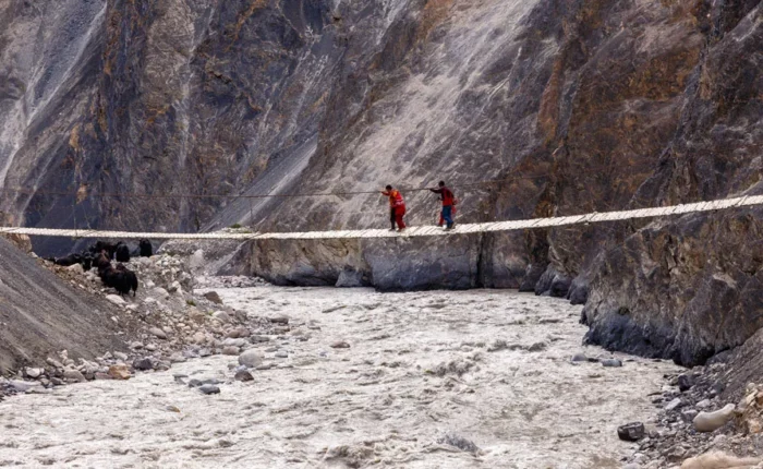
Crossing the Gujerav and Chafchingol rivers may require fixing ropes across the rivers for safety. Descending the Chafchingol Glacier requires bringing the mountaineering equipment Necessary to fix at least 150m of rope and possibly travel in roped teams (See Mountaineering Equipment,).
Day 01: Trek Shimshal Village to Zarthguban
Head east from Shimshal, cross Michael Bridge, and continue through the cultivated area of Band-e-Sar. Turn north into the steep, narrow canyon formed by the Zarthgurban River, 1 ½ hour from Shimshal village. The trail begins along the river’s true right bank, crosses it four times, and in 1½ hours reaches Pasth Bar (3360m) with a spring below the trail. Shau is a woody shrub with yellow flowers used to make weaving spindles. Tung-e-Ben, a sheltered flat place, is five minutes beyond.
Cross the river a final time to its true left bank and ascend a 250m steep scree slope 45 minutes to a wooden portal (3600m) called Tuong-e-Sar (the top of the difficult dry area). Beware of rockfall on this tricky scree slope. A clear stream lies 15 minutes beyond. Continue 30 minutes to the broad, level plain of Zarthgurban (4075m). The yellow cliffs above Zarthguban are the source of its name, which means at the base of (ben) the yellow (zart) rock (gar). This dramatic campsite has a herders’ hut. The entire enormous valley is an old lake bed formed by a huge rock slide that dammed the valley. The cliffs frame views south to Shimshal and Adver Sar. 4-5 hours, 6.9km, 1075m ascent
Head north from Zarthguban, fording the stream that descends from Uween-e-Sar. Stroll across the maidan and, towards its far end, descend to and ford the Zarthgurban River to its true right Bank. Immediately the trail climbs to traverse black moraine from a side glacier.
One across the moraine, the route diverges. When the water in the Zarthguban River is very low, you can immediately descend to the river, ford it and avoid crossing the side stream coming from the west. When it’s low, descend to the level plain formed by the side stream before descending to the river. Then follow the true right bank and ford the Zarthguban River above the side stream. Once across the river, follow its true left bank to the lone hut (4471m) at Shpodin (place where rhubarb or shpod grows). Follow the river’s edge one hour to Jahparwashik (4602m, where a man, Jafer, built a stone wall around fields). When the Zarthgurban River is high, stay on the true right bank and ford the side stream. Continue on the river terrace high above the true right bank, and ford the Zarthgurban Rivera few minutes below Japerwashak. High cliffs provide a spectacular backdrop to this grassy flower-strewn spot, home to ibex. 4 hours, 8.4km, 527m ascent
Day 03: Jaerwashak to Perchodwashk – MandiKshlakh
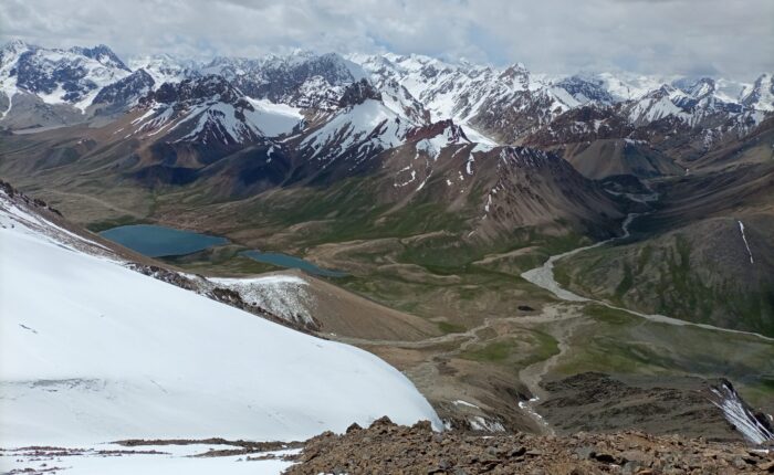
It takes 1½ to two hours to climb to the east-west Boisam Pass (4875m). The trail basically follows the true left bank of the stream descending from the pass, crossing and then recrossing it just before the final steep, rocky push to the pass. In high water, it requires a ford. Boisum means the pass above (sum) the caves (boi). It refers to the overhanging clefts at the base of the fissured cliff (on your right as you ascend) on the southwest side of the pass, which was the overnight stopping place on the two-day journey between Shimshal village and Gujerav long before any shelters existed at Shpodeen or MandiKshlakh. Attractive Pir Peak (5915m) rises east-south-east of the pass.
Immediately below the west side of the pass is a tarn called Lup Zhui. Either skirt the Shrinking lake’s northwest shore or cut across the dry section of the lake bed in 15 minutes. Cross the low rise beyond the lake to Shipkadurikh, an outwash plain, another 15 minutes farther. Beyond this is another rise that descends steeply on the moraine to a vast, level outwash plain. Cairns mark the indistinct route, which takes 30 minutes to follow to the shore of the smaller Dzak Zhui. Past this lake, the trail moves onto moraine rubble and descends reasonably gently one hour to Perchodwashk beneath gigantic black terminal moraine that fills the valley. Built against an erratic is the hut (4580m) at Perchodwashk (meaning ‘where the young girl got tried’) above the confluence of two streams, which are usually silty, amid pleasant meadows. 3-4 hours, 10.2km, 273m ascent, 295m descent
Day 04: MandiKshlakh to War-e-Ben
Between MandiKshlakh
three tongues of rocky rubble from side glaciers push into the Boisam Valley from the west. Between these obstacles are two grassy plateaus with clear streams and dilapidated structures called Qul Beg Maidan and Reza Maidan. From Perchodwashk, ford the side stream and stay close to the river’s true left bank, skirting the first side glacier. Stroll across flower-carpeted rolling hills marked by cairns and in 1km pass two possible camp sites, Shogshogeen, named for yellow buttercups that yaks like to eat, and nearby Pamireen.
Beyond Pamireen, traverse Qul Beg Maidan and cross the second side moraine. The trail crosses the two-level terraces of Reza Maidan, dotted by ochre lichen-covered boulders, and the last side moraine. Here is the first dramatic glimpse of the rocky Ghuzherav. An imposing vertical precipice soars high above the Boisam River’s true right bank. MandiKshlakh (4129m), an unattractive cluster of huts and livestock pens on a dusty, stark terrace, is two hours below Perchodwashk at the Boisam Valley’s mouth.
Leaving the Boisam Valley, the route turns west into the Gujerav. When the water level in the Gujerav is low, the trail stays along the river’s true left bank to Avduzhi. When it’s high, you must ford the broad river twice-across and then back to the true left bank-to bypass a section under water. One hour west of Mandiqshlakh is Avduzhi (3871m) with its huts and a clear stream. Beyond Avduzhi, along an easy trail, lies War-e-Ben (3597m), Gujerav primary summer settlement. Because yaks can’t cross Chafchingol Pass, they don’t go beyond War-e-Ben. 4½-5 hours, 14.1km, 983m descent
Additional Side Trip: Dih Dasht and Spesyngov-e-Desht 2-4 Days
From War-e-Ben, you can continue north-west down Ghuzherav through junipers to the summer settlement of Dih and Spesyngov. From Dih, a side valley rises south to the pastures of Dih Dasht where ibex and blue sheep are reportedly plentiful. From Spesyngov, another side Valley leads south to Spesyngov-e-Desht beneath Quran Koh’s snowy summit (7164m). Beyond Spesyngov, a low-water route, passable between November and May, follows the Gujerav to its confluence with the Khunzherav. Another route to Sost over high, extreme passes is definitely inadvisable for trekkers. It’s two days and four stages one way between War-e-Ben and Spesyngov-e-Desht, and half that to Dih Dasht.
Day 05: War-e-Ben to Chafchingol Pass Base Camp
Cross the Ghuzherav by an existing steel cable when the water is high or by wading when it’s low, and enter the Chafchingol gorge. The country here is high desert with crumbly, desert-varnished granite and junipers. When the water in the Chafchingol River is high, typically three and possibly as many as five difficult fords of the river are necessary. It may require fixing the rope for safety.
Once through the gorge, the trail thins, rising above the river and crossing scree slopes to descend to Targaryen (where tamarisk grows,) where a small cramped hut sits by the stream (3870m), two to three hours from War-e-Ben. Beyond Targaryen is the confluence of a stream from the west and another from the glaciers at the Chafchingol’s head. Ford the western stream and continue to Chafchingol Base Camp (4084m), a site with some low stone wall shelters, two hours from Targaryen. Clearwater is near the river. It is possible to climb Sonia Peak from Chafchingol Base Camp (see the boxed text ‘Peak Possibilities’)
Day 06: Chafchingol Base Camp to cross pass to Koksal River KKH
6-7 hours, 6km, 1016m ascent, 680m descent
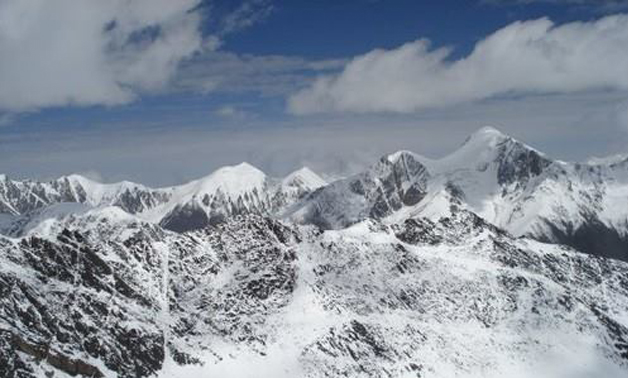
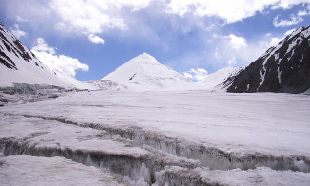
It’s a long, arduous day, so start early. The ascent over scree to the permanently snow-covered Chafchingol Pass (5100m) takes four hours. It’s steep Class 2 near the top with loose rock. The pass, marked by a large cairn, is glaciated on its north side. The descent is steep. Early in the season, snow covers a large bergschrund at the glacier’s west margin and the route goes down the snow and requires fixing a rope for safety and probing for crevasses. Late in the season when the Bergschrund is open, the route descends the rock cliff on the glacier’s west side. The rock route may require a short rappel (abseil) or fix as much as 50m of rope for safety.
Once off the glacier, cross to the Chafchingol stream’s true left bank. A small rocky area provides a spot to make tea or camp if it becomes too long a day. From this spot, follow the Chafchingol stream down to its confluence with the Chap Dur and Koksil rivers (4420m) and camp along the Koksil River.
Peak Possibilities
Sonia Peak
Accessible from Chafchingol Base Camp (Day 5)
West of the Base Camp, towards the Chafchingol Valley’s head, rises Sonia Peak (peak 6340m on the Swiss map), first climbed by Shimshal Rahmat Ullah Baig. The three-day technical climb of 2256m ascent and 2256m descent is gaining popularity. On the first day, follow the river’s true right bank for three to four hours from Chafchingol Base Camp to Sonia Base Camp, the high camp. The second day is a long ascent on the glacier to the snowy pyramid’s summit, returning to Sonia Base Camp. On the third day, return to Chafchingol Base Camp. 4-5 hours, 10km, 487m ascent
Day 07: Kokssl River to Koksil KKH
From the confluence, it takes two to three hours to reach the KKH, the KSF check post, and herders’ huts at Koksil (4410m). 5-6 hours, 4km, 10m descent
+92-3474598096
info@rockvalleytours.com
+92-3474598096
info@rockvalleytours.com

